Student Spotlight: Morgan Young
December 11, 2015
We had the opportunity to sit down with year-one Environmental Technologies - GIS student, Morgan Young, to talk about the program.
Can you tell us a little about yourself? Where did you attend high school?
Hi my name is Morgan Young and I’m taking in the first-year of the Environmental Technologies – GIS program at ACC. I grew up on a farm near Nesbit, a small community just south of Brandon—I still live in Nesbit and drive to Brandon every day. There isn’t a high school in Nesbit so I actually attended Crocus Plains Regional Secondary School in Brandon.
What made you decide to come to ACC? Why did you choose Environmental Technologies – GIS?
I love it so far. I actually started my first couple years of post-secondary education at Brandon University taking Psychology, but decided it just wasn’t for me. Farming has always been a big part of my family so I wanted to find something to do, which relates—not necessarily farming or agriculture itself though. I did some research and found the Environmental Technologies – GIS program which seemed to fit my interests and what I wanted to pursue as a career. I applied and now here I am!
There seem to be a lot of career paths I can pursue after I graduate; jobs in agriculture, oil and gas, working with municipalities, conservation districts, or working with a city.
Have you always been interested in this type career and the outdoors?
Growing up in the country I’ve always enjoyed working outdoors—whether it be doing chores on the farm or feeding the horses. A good portion of my time growing up was spent outdoors, which makes the program a natural fit for me.
How has your experience been so far?
So far it’s been absolutely fabulous! The first term we did a lot of labs with students in the Agribusiness program. Labs related to ecology, plant identification, and other things that we’re going to need to know before we can start doing other tests and projects later down the road in the program. We also share many of the same classes with the Land and Water Management program. Right now we’ve been learning about water resource, plant science, geographic information systems, and cartography. It’s not until next term that we start to branch off and begin learning things specific to the GIS specialization, courses like Database Management.
Has anything surprised you about the program so far?
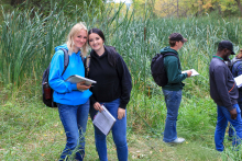
I was really surprised with how many courses and labs we shared with the Agribusiness and Land and Water Management program at the start of year. We were going on agroecology tours across southwestern Manitoba with two buses full of students. We went to Rosedale, Shilo, Wawanesa, and other locations to tour and do field tests at places like potato farms, Manitoba Beef and Forage locations, and Ellis Farm Supplies. Another really interesting location and field lab we were part of was going out to the Yellow Quill Prairie Nature Conservancy near Shilo to do a lot of animal track and fence marking research.
Are there any projects you’re working on right now or have worked on in the past that you can tell us about?
As one of our final projects we’re creating a map for the Rural Municipality of Oakland to show erosion potential. We’re creating a map with layers to show different soil types, water drainage, and a couple of other things. We combine them all to make a final map and report based on the data and information we gather.
We did a lot of other smaller projects, which were similar but mainly focused on one layer at a time. This is the first project where we’ve combined multiple layers and data.
You use a lot of different instruments and computer programs. Can you explain a little about what you’ve been using in the classroom? What’s your favorite?
For GIS so far we’ve mainly used a program called ArcMap which we use to input data we gather. We can also use different options to manipulate the data and create fly-throughs where you can get a point of view through the terrain you’ve mapped out and created.
We often use a handheld GPS for a lot of our field labs that we do. We also started to learn basics information regarding drones but we’ll get more into that in the second-year and actually get some hands-on experience.
I’ve had a little bit of prior experience using a GPS at home and in high school but nothing quite like this.
What are your classmates and instructors like?
Right now we have a large class if you count with students from other programs we are grouped with taking similar classes. The GIS program is a much smaller group on its own though. Our class really clicks; we do a lot of stuff together. If one of us needs help there is always another person looking to help.
Our instructors are really great too and are always there to help us out.
Is there anything in particular you’re excited to learn about?
I’m not really sure yet. Next term we have a Database Management course, which will be cool to learn since we haven’t done much with databases yet. I really like learning about how things work and it’ll be great to finally work with databases and see how they apply to other things I want to learn and do
I understand the program involves a Co-op work placement. Have you put any thought into your placement?
We were just recently at the Manitoba Conservation Districts Conference, and a big portion of it was networking. I know the some people at Ducks Unlimited Manitoba and I was looking at possibly working with them for my co-op placement next year. There are many places I wouldn’t mind working at for my placement—West Souris River Conservation District or Green Aero Tech. With Ducks Unlimited or a conservation distract it would involve a lot of data collection, creating maps, and reporting. I’m looking for a mixture of indoor and outdoor work.
Did you do anything to prepare yourself coming into the program? Do you have any advice for other people looking to take GIS?
Nope (laughs). I knew a little about what to expect from the research I did online looking at the types of jobs I could get with the education. Other than that I didn’t really know what to expect.
Take it. If you’re undecided between any of the courses or even between the Land and Water Management or the GIS programs don’t worry too much because the first courses are shared for the most part. There are so many career paths you can take once you’re done the program.
The program is also really computer oriented. So, if you were looking at taking the program some prior knowledge with computers would help a lot.
Do you have any plans for after graduation?
I’m just looking to start my career. It could take me anywhere across Canada and I hope it does, but at first I’d like to stay within the province. After I get some experience I’d be up for moving anywhere, especially out west and find some work out there.
What’s something about you that would surprise people?
Probably the fact that even though I might appear to be good at speaking in class and act socially in most situations I have still somewhat of an anxiety problem. Being in a classroom constantly surrounded by my classmates was a huge shock to my system at first.
Are you involved in any activities outside college?
I currently work five different jobs; every morning I do respite work with children, I work for Friends Fur Life Daycare casually, do professional dog showing and training, and also work at Sobeys in Brandon. I work a lot.
What’s your favorite food?
Spaghetti.
Do you have any favorite TV shows/movies or hobbies?
I’m really big into Disney movies. The new Cinderella movie was awesome.
In my spare time I do a lot of horseback riding. We’ve got four horses on our farm so I spend a lot of time with them.


